The Marianna Lions met Monday August 23rd at Jim’s Buffet and Grill. During the business session a letter from the Chipola Foundation recognized the Lions scholarship contribution. A thank you letter was received from Jessica White regarding her receipt of the club scholarship. The board meeting was changed to September 13th
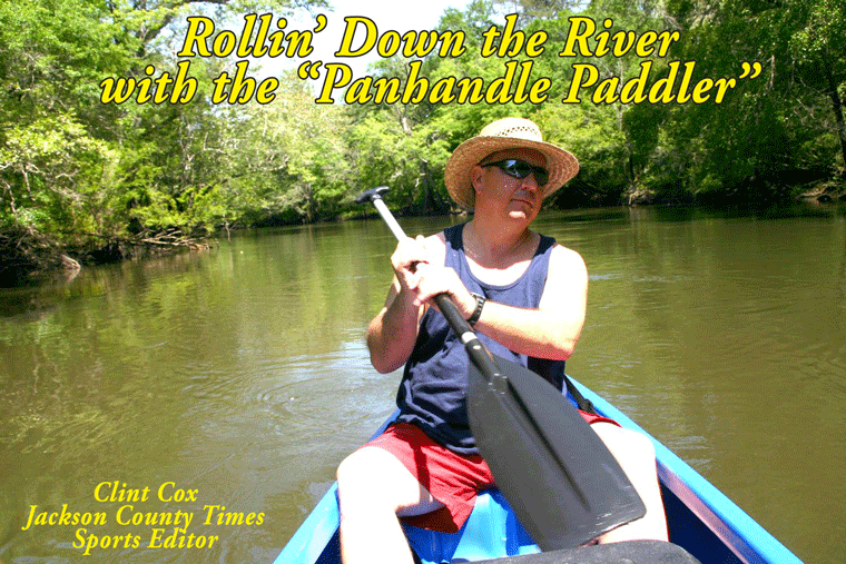
Clint Cox presented an interesting, entertaining and nostalgic PowerPoint presentation entitled “Rollin Down the River, Panhandle Paddler” His trip was instigated as a result of a story that Dick Hinson told of his and Sonny Anderson’s trip on the Chipola several years earlier. Clint and Chris Mathews took their trip in 2008-09. They took the river a section at a time consisting of 11 segments over 14 days and three nights. Clint first went up the river to its origin at Marshall and Cowart’s Creeks. This area of the river is log and limb strewn and infested with gators. As he took us under storied bridges such as Bellamy, Yancey, and Magnolia bridges, and several railroad trestles he pointed out his colleague’s debunking of ghost stories and the fact that several of these bridges were places that young Jackson, and I presume Calhoun and Gulf County, boys, had to prove their manhood by jumping off a bridge. Several Lions raised their hands, silently testifying to their rite of passage.
This reminded me of our son and a friend who were either testing themselves or trying to earn a merit badge, canoed down the Chipola and coming out of a log run, their canoe capsized, resulting in loss of a pair of glasses and shoes much to their parents consternation. Other sites shown included Christoff’’s Ferry which had a hotel that was built in the 1830’s, Federal Shoals that had a fort and local Indians used Alamo cave as a hiding place. Judge McCrary’s river house was shown, supposedly in a 50 year floodplain. The good judge said that “it made him 250 years old”.
Needless to say the 89 miles of the Chipola from its origins to where it joins the “Big River” below the Dead Lakes, is very storied. The Chipola is also very popular, attracting about 2500 people in tubes, canoes and kayaks on any warm weekend. There are several good internet sites with stories about Panhandle rivers. Including Clint’s Rollin Down the River, Panhandle Paddler and “Voices of the Apalachicola”.
Click Here to go to our Homepage
Thursday, August 26, 2010
Friday, July 2, 2010
Rollin’ Down the River – The Dead Lakes to The Big River – Part II
By Clint Cox,
alias “The Panhandle Paddler”
Last week we left off our journey on the final leg down the Chipola at Burgess Creek. Traveling south of Burgess Creek the next major stop was that of Lockey Lake. This “lake” comes into the Chipola on the west side and has a nice boat landing known as Bryant’s Landing. My traveling partner, Chris Matthews, and I took a break for lunch here before spotting an interesting site across from the landing. We took note of several “contraptions” that demanded a closer inspection. These contraptions turned out to be swamp logging devices (photo attached) that were anchored up in a little slough.
Just a short paddle from Bryant’s Landing is Douglas Landing on the west bank. This is a small “fish camp” style landing with a concrete ramp and several locations for overnight camping. Another landing on the west bank was spotted just down from Douglas and it is known as Lister’s Landing. This is a small dirt landing but appeared to be in good shape. Across from Lister’s Landing on the east side is Douglas Creek, which loops around and comes back out about a ½ mile down on the east side of the river.
Buck’s Brite was the next site that we checked out and it is a creek coming in on the west side of the river. The creek features a nice sandy beach, swimming area and camping spot. It also featured a house boat tied up at the mouth of the creek. Just a short paddle down from Buck’s Brite we came to the meeting place of the Chipola and Apalachicola River. The two rivers come together just 27 miles north of the town of Apalachicola.
Chris and I checked out a potential camping spot on the Big River but decided to return back up the Chipola to Buck’s Brite for the night. Part of the reason we went back up river was due to a difficult decision that we had to make. The dilemma was whether to paddle down the Big River to the next take out point or paddle back up the Little River to Douglas Landing for our take out the next day. Obviously paddling down river would have been much easier, but there are no take out points on the Big River in close proximity to the Chipola and Apalachicola’s meeting place. So back up river we went and Buck’s Brite turned out to be a right nice camping spot, complete with good shaped, a good swimming hole and a beautiful river front view. That also meant that the next morning was spent paddling back up river to Douglas Landing. That was a tough little paddle but we made it and were able to hitch a ride back to our vehicle for an early exit.
Two interesting aspects were noted on this lower section of the Chipola. First the presence of numerous house boats. Very few turns were taken without the revealing of another batch of these floating houses tied off to the bank. And these floating houses took on every imaginable shape, size, color and condition. The other interesting aspect noted was the style of fishing that we observed. As I mentioned last week this portion of the river has little to no banking. The banks are made up mostly of a variety of trees and bushes hanging out over and even on the water. The folks that fish these parts pull right up into, and amongst these trees and bushes. Casting is out of the question, so they just tight line fish with rod and reels right next to their boat. Given the number of heathly moccasins that we saw down here, I’ll pass on this fishing technique.
With the journey down the Chipola River complete, I take some time over the next couple of weeks to share a few thoughts, and of course more photos, about my journey.
Friday, June 25, 2010
The Dead Lakes to The Big River – Part I
By Clint Cox, alias “The Panhandle Paddler”
For the past two summers we have paddled the Chipola River from her headwaters in Northern Jackson County to the Dead Lakes in Gulf County. The final leg of the journey was to paddle from the southern end of the Dead Lakes to where the Chipola meets up with the Apalachicola River. Folks in Gulf County like to keep it simple so the Chipola is known as the Little River and the Apalachicola is known as “The Big River”. Once again my traveling companion was Chris Matthews, a local veteran with a wealth of paddling and outdoor experience.
Our journey started with a night spent at the Sportsman’s Lodge just outside of Wewahitchka. The lodge and their boat ramp are located right on the waters of The Cut, an off shoot of The Big River that connects with The Little River just below the end of the Dead Lakes. We shoved off our canoes, loaded with our camping gear, early the next morning to a back drop of a beautiful spring morning sunrise. Within moments we had hooked up with The Little River and were on our way.
The eastern banks of the Little River below the Dead Lakes really amounts to an island. This island, which alternates as dry land and swamp land, is surrounded by The Big River, The Little River and The Cut. The most immediate difference in the Chipola down this way is the coloration of the water, which has been darkened by the influx of The Big River. The banking is also very different in that there is practically no banking to speak of. Again the eastern bank is mostly swamp land. The western banking is very low and lined with trees hanging over the river. The western bank also features a fair amount of development along the way. Maddox Slough follows some of these housing areas about an hour south of the Dead Lakes.
Just down from Maddox Slough is an unusual site for this portion of the river. The western bank displays a high bank that is at least 50 feet high and last for about 200 yards. The river then returns to her look of low to no banking with the next notable site a public boat ramp known as Land’s Landing. Shortly thereafter we see a slough to the east, which is called White River and then a creek, Burgess Creek, to the right.
At this point we have paddled about half the distance of this trip. We’ll take a break for this week and come back next week with Part II of our journey to The Big River.
Monday, August 31, 2009
Dead Lakes To The Cut
By Clint Cox, alias “The Panhandle Paddler”
The journey through the Dead Lakes continues this week. I’ll begin this portion of the journey at the area known as West Arm Creek. This dark water creek enters the Lakes from the west and if you are traveling south on Highway 71 you will cross over this creek just before entering the town of Wewahitchka. The creek has many of the same features as the Lakes, with its dark waters and vast graveyard of cypress stumps. As you travel south through the lake you’ll approach West Arm Creek at a landmark known as 5 Stumps. These 5 stumps are found on the northern tip where the creek meets the lake. You’ll know it is West Arm Creek when you see one of these stumps with a black and white ribbon / banner tied around the stump. In fact, there are three or four stumps in and around the creek entrance that have these same black and white ribbons / banners. I paddled about a ½ mile up the creek and it looked to be a prime fishing location, as is much of the Dead Lakes.
In paddling through the Dead Lakes we have been primarily hugging the western shoreline. At West Arm Creek the journey moves toward the eastern shoreline to find a clear channel. This channel however will eventually come to a dead end. When it does, head due west until you catch sight of the Dead Lakes Bridge on Lake Grove Road. When you see the bridge, return to the eastern shoreline to find the main channel. This main channel will take you under the bridge and over the remnants of the old man made dam.
As I wrote last week the Dead Lakes were created naturally over the course of many years. The sediment-laden Apalachicola River deposited its silty sands over its banks, causing a slow-motion jam that eventually created a natural dam on the Chipola River. The ensuing high water from the Apalachicola in the floodplain killed thousands of trees, thus the name Dead Lakes. A man made dam was constructed in 1962 to help maintain a high water level however it was torn down around 1987 when it was realized that the man made dam was doing more harm than good. As I paddled under the bridge, with at least 8-10 feet of clearance, I recalled seeing a picture taken by Dick Hinson in 1986 of Sonny Anderson and his canoe as he went under the bridge with only about two inches of clearance. That was before the dam was removed.
About 200 yards south of the bridge is The Cut, which is where the Chipola River is joined by a segment of the Apalachicola River. The Big River splinters off from its self about a mile upriver and this splinter connects with the Chipola, overtaking The Little River and turning the waters to a muddy red coloration. From here the Chipola, with its new red look, flows 18 miles south to join up with the main channel of the Apalachicola River.
Rollin’ Down the River has been a weekly summertime feature of the Jackson County Times which highlights the Chipola River through pictures, stories and articles. See Simply Put for more on the conclusion of this series.
Scott’s Ferry To The Dead Lakes
By Clint Cox, alias “The Panhandle Paddler”
Departing from Scott’s Ferry early on a beautiful Sunday morning, Chris Matthews and I began our journey toward the Dead Lakes. South of the Highway 71 bridge there are several sloughs, one of which includes a very large house boat that is rumored to house a full size pool table. On down the river there are numerous houses on the east side of the river and the eastern banks are high while there are almost no banks on the western side.
The river goes through several changes in this section, going back and forth from being a wide and slow moving river to being much more narrow and picking up speed. About an hour paddle below the bridge the river forks, with the left fork going around an island in a horseshoe fashion. Stay to the right if you want the quicker route and continue on as the river begins to narrow again, traversing through several willow runs. Coming out of the willow runs are more sloughs and many cypress stumps that give indication of logging in years past. This widening and narrowing of the river continues for several miles but we eventually come upon a bend with several nice houses and a pretty good size creek coming from the east. That creek would be Cypress Creek and that indicated we were now in the upper portion of the Dead Lakes.
The Dead Lakes were created naturally over the course of many years. The sediment-laden Apalachicola River deposited its silty sands over its banks, causing a slow-motion jam that eventually created a natural dam on the Chipola River. The ensuing high water from the Apalachicola in the floodplain killed thousands of trees, thus the name Dead Lakes. A man made dam was constructed in 1962 to help maintain a high water level however it was torn down around 1987 when it was realized that the man made dam was doing more harm than good.
With Chris leading the way, the paddling plan was simple. Hang right all the way down the lake. If there was ever a place that a person wanted to get lost, the Dead Lakes would be a prime location. But with a GPS and a map of the lake we made our way safely down the western shoreline. The lake begins to widen out significantly with more cypress stumps than you can imagine. There were several notable landmarks along the way that reassured us we were on the right path. Those landmarks included Brown’s Creek, a sunken barge, Cypress Lodge and an Eagle’s Nest. There were also a couple of unusal landmarks that included a twisted cypress tree that looked like an ice cream cone and a string of gordes up in the trees.
By midday we had reached our take out location, which was an old fishing camp that we were able to access thanks to Sam Mattraw. We had made it about two-thirds of the way down the Dead Lakes but our day was over. So tune in next week for the final leg of the journey through the remainder of the lake and the end of the Ole Chipola River.
Rollin’ Down the River is a weekly summertime feature of the Jackson County Times that highlights the Chipola River through pictures, stories and articles.
Monday, August 17, 2009
Highway 20 Bridge To Scott’s Ferry
By Clint Cox, alias “The Panhandle Paddler”
This week’s paddle adventures began at the Highway 20 Bridge with Greg Lambe serving as our chauffeur (on land) and Chris Matthews once again serving as my traveling companion, and more importantly on this run, as my guide. The river was somewhat muddy due to recent rains but early traveling weather was enjoyable. This portion of the river is much wider with numerous sloughs, especially on the eastern side. Numerous house boats were observed along the way as well as some screened houses or pavilions.
Several creeks were noted along the way and like the sloughs most enter from the eastern banks as the western banks were usually much higher. But then the high banks switch sides and we came up on a bend that had extremely steep banks on the east side. These banks, at least 75 feet in height, were covered in various forms of vegetation (ferns, wild honeysuckle and mountain laurel) but you could hear spring waters trickling through the lime rock as it made its’ way down to the river. Just across from these banks was a nice little sandbar that we stopped at for a snack and to rest our bodies. A closer inspection of the banks revealed the clear waters trickling into the river and the lime rock displayed shelled fossils from it’s’ days of being under ocean waters.
About 10 minutes down from this area is a small tea colored creek entering from the east. There is a swing, complete with a launching stand and just up creek is a beaver dam, which made for a nice little water fall. We then began to encounter “Willow Way”, a long stretch of the river in which Willow trees border both the east and west banks. It was along in here that we had our first gator sighting and we trailed this 7 or 8 footer down the river for at five or six bend before he had enough of us and submerged into the murky waters.
The river begins to change as it becomes narrower and splinters off into numerous sloughs with little to no banking. This last for about a mile and then the river reforms with more of a channel and banking. This occurred just as we approached Jehu Landing, a dirt boat landing on the east bank. A little further down we went back through another narrow stretch with more sloughs splintering off. We came out of this stretch to find numerous RV campers on the east bank and Beck’s Lake, a large slough, on the west bank.
About five hours paddle below Highway 20 we came to the area known as Ward Lake. This is a stretch where the river splinter’s into a series of sloughs and narrow runs. When you encounter a sign that says Ward Lake pointed to the left, go right. All the locals will tell you to enter Ward Lake only if you positively know your way around. Going right will led you to a run that will take about an hour and will get narrower the further south you travel. Some parts are so narrow and shallow that only a canoe or kayak could make it through. We encounter two log jams, one of which we had to disembark and pull under a fallen tree. Chris assured me that we were on the right stretch and that a wider river would reappear soon.
And just when I thought the river might completely disappear, we came out from this narrow passage back into open waters. And around the next bend was the Highway 71 Bridge and Scott’s Ferry. We spent the night at Scott’s Ferry in one of their river cabins. They have 5 cabins built up on stilts and have varying levels of accommodations. Our cabin had a double bed, sleeper sofa, microwave, small refrigerator and a bathroom with a shower stall. After spending the day on the river, in a kayak and in the rain, the hot shower and air conditioning usually would have been the most valuable players. But the MVP turned out to be of a different sort. (See Simply Put)
Join us next week, we’ll journey from Scott’s Ferry to the Dead Lakes.
Rollin’ Down the River is a weekly summertime feature of the Jackson County Times that highlights the Chipola River through pictures, stories and articles.
Monday, August 10, 2009
Lamb Eddy To Highway 20 Bridge
By Clint Cox, alias “The Panhandle Paddler”
Our summertime stroll down the Chipola River continues this week with the run from Lamb Eddy to the Highway 20 Bridge. My traveling companion, Chris Matthews, and I made this trip on a June Sunday morning after camping the night before at Lamb Eddy. In last week’s feature I commented that I did not know the origins of the name Lamb Eddy. One of our readers, Nadine Standland called to provide the information. Lamb Eddy was named after John Lamb, who lived on the west banks of the eddy. His brother lived on the east banks of the eddy. John Lamb’s father-in-law was William Peacock, the great great grandfather of Standland. We started out with a beautiful blue sky over our heads and the Ole Chipola beckoning us to spend the day in her company.
Just below Lamb Eddy there is quite a bit of development on the west bank but the east bank remains mostly undeveloped. Just over a mile below Lamb Eddy is a concrete boat landing, known as New Landing on the east side. From that point southward the housing build up switches sides as the east bank is developed while the west bank is undeveloped. The river also begins to widen out some here and slow down. About an hour paddle below Lamb Eddy we observe Ten Mile Creek meeting up with the river from the west bank side. This tea colored creek has some very interesting lime rock formations that guard its’ bank for almost a ¼ mile up creek. This creek, which I suspect is about 10 miles long, runs all the way back up to Highway 73. Just south of Ten Mile Creek several smaller creeks were seen, one on the west bank and one on the east bank. It was along in here that we noticed an unusual lime rock formation on the east bank that appeared as if it had a shelf running parallel with the river for about 75 feet.
We stopped for lunch at a small creek entering from the east called Farley Creek. It had a nice little sandy beach area but it was most easily noted by a concrete bridge over the creek just a few feet from the river. We had a nice visit there with a nice young couple whose family owned the property. They had brought their new Labrador puppy down to the river for a dip. There’s nothing like a puppy and the river to coax total strangers into an enjoyable chat. On down a ways the river widened out even more and we noticed a lot of bamboo on the west bank. Right after the bamboo forest we came upon Four Mile Creek. This creek, which is tea colored like Ten Mile, enters from the west about four miles below Lamb Eddy. The river was clear and shallow here and it made for a great cooling off dip.
Past Four Mile Creek there are some really high banks on the east side, some at least several hundred feet high. It had a feel almost like we were paddling through a gorge in the mountains of North Carolina. After departing the high banks area, the river returned to its’ normal look and as we neared the Highway 20 Bridge we spotted some nice sand bars. One particular sandbar was rather large and hugged the west bank a few bends above the bridge. Several smaller sandbars, and a slough called Gator Slough, were stationed just north of the bridge.
Join us next week, we’ll journey from the Highway 20 Bridge to Scott’s Ferry.
Rollin’ Down the River is a weekly summertime feature of the Jackson County Times that highlights the Chipola River through pictures, stories and articles.
Thursday, July 30, 2009
Big Look and Tremble To Lamb Eddy
By Clint Cox, alias “The Panhandle Paddler”
Our journey down the Chipola River, now well into Calhoun County, picks up at the area known as Big Look and Tremble. As I wrote last week this is a shoal area of the river that, when the water levels are low, makes for a Class I or sometimes even a Class II type rapid. The best way to make you way up or down the rapid is to run close to the eastern banks.
Just below Big Look and Tremble we came up on a large contingency of boats (about 10) that were anchored next to a house boat, aka party barge. They were all having a large time and not feeling much pain. The river widens out along this stretch and is fairly deep. That combination makes this very popular for motorized boating and on the weekends there is quite a bit of boat traffic on the river. I also learned that Spring Creek is not the only popular tubing run on the river. The stretch from Johnny Boy’s Landing to Lamb Eddy is also very popular with the tubers and we saw at least a 100 folks enjoying the river via tubes. They also share a common trait with the Spring Creek tubers in that it is a big party scene for most of them.
About an hour below Big Look and Tremble is an area known as Lamb Eddy. In river terms an eddy is a current of water moving contrary to the main current in a circular motion. Lamb Eddy is located at a big bend on the western bank of the river. When I inquired as to how this area was given it’s name, I was told that it had something to do with a former Judge in that area. I don’t know if that is factual or not, but with the lay of the land and the river, there is no doubt there is more than one eddy in the area. Lamb Eddy encompasses about 3 acres of land which is well kept and has plenty of shade. It includes a public boat ramp, a swing and large clear cut grassy area that provides for plenty of parking. We made camp at this site and I’m told that while camping is not officially allowed, nothing will be said as long as the campers don’t cause any problems. With the large contingency of boat traffic and tubers taking out at the landing, there was a lot of vehicular and pedestrian traffic going and coming. By evening though most of the party crowd had left and it was fairly quit. That is until about 2:00 am when the party crowd returned with loud trucks and music. They finally departed about 4:00 am and we were able to get back to sleep. If you are looking for a quite little spot to camp on the river during a summer weekend, Lamb Eddy ain’t it. But during the week or in the fall and winter, it would make for a right nice spot to pitch a tent and spend the night.
Join us next week, we’ll journey from Lamb Eddy to the Highway 20 Bridge.
Rollin’ Down the River is a weekly summertime feature of the Jackson County Times that highlights the Chipola River through pictures, stories and articles.
Thursday, July 23, 2009
Johnny Boy’s Landing To Big Lookin’ Tremble
By Clint Cox, alias “The Panhandle Paddler”
Picking up at Johnny Boy’s Landing, which is where we left off last week, grab your paddle as we, Chris Matthews and I, journey southward down the river. Just a few minutes south of Johnny Boy’s is a clear spring that enters the river from the east bank. Several large lime stone boulders surround the spring, as if to serve as guards to the pristine waters flowing out of the banks. Several sinkhole type springs can be found close by on land. Around the bend is another spring entering from the east and also has some large limestone formations guarding the entrance. We made our way up this spring run a little ways but never found the spring head. With the water levels near normal, we also spotted a small cavern in the lime rock bank on the east side that you could park your canoe in and almost completely be hidden. I also noted that this section of the river features some high banks, especially on the eastern side. About a mile and a half below Johnny Boy’s we passed under Willis Bridge. This bridge is on county road 274 that connects Altha to Shelton’s Corner.
After paddling about 20 minutes below Willis Bridge we encountered one of the more famous landmarks on the Chipola River. Known as Big Lookin’ Tremble, this rapid section of the river has spilled many a canoe into the cool waters of the Chipola. Big Lookin’ Tremble takes on different looks depending on the water levels. During high water levels travelers can pass over the area and barely notice the change in currents. During low water levels this can be a Class II type rapid, especially if you are brave enough, or crazy enough, to take it head on in the middle of the river. The water levels were about normal on our trip and after a brief stop to scout the situation, we made our way toward the eastern side of the river for a non-eventful ride down the little rapid. Given that our canoes were full of our camping gear for the night, a non-eventual ride down the little rapid was just fine with me.
Join us next week we’ll journey from Big Lookin’ Tremble to Lamb Eddy.
Rollin’ Down the River is a weekly summertime feature of the Jackson County Times that highlights the Chipola River through pictures, stories and articles.
Thursday, July 16, 2009
Tater Hill To Johnny Boy’s Landing
By Clint Cox, alias
“The Panhandle Paddler”
“The Panhandle Paddler”
We left off last week at Tater Hill, so that is where we’ll pick back up this week. Departing Tater Hill the river meanders at a leisurely pace pass some interesting landscapes and backgrounds. A few bends below Tater Hill there is an intriguing lime rock shelf formation on the east side of the river. Next up on the agenda is what the locals refer to as Hall’s Landing. Apparently this used to be a very popular hang out for the locals, much like Tater Hill. There is a nice little sandy beach area and the remnants of a swing that has clearly seen it’s better days can still be spotted dangling from one of the big oak trees towering over the water.
Paddling on down river about 30 minutes or so there is a spring that enters the river from the east side. My traveling companion, Chris Matthews, and I chose not to explore this run but I made sure to snap a few shots of the clear spring water as it blended into the Ole Chipola. In another 15 minutes or so of paddling we began to see some houses, primarily on the west banks. For the most part, from Peacock’s Bridge to where we saw the first house, which is about 5 miles run, the river was absolutely pristine with no development on either side. I suspect that this stretch of the river looks much like it has for hundreds of years (no wonder this is one of my favorite stretches to paddle).
Once houses have been spotted travelers will know they are getting close to civilization again. Within a few bends you will encounter one of the great landmarks of the Chipola River. Johnny Boy’s Landing has been around for as long as I can remember. It is located several miles west of Altha, just off of County Road 274. Johnny Boy’s has long been associated with having a great swing. Be forewarned though, depending on the water level, you must either swing out over dry land or very shallow water to reach water deep enough to launch into the river. Johnny Boy’s has also long been associated with a lot of partying. While the landing includes a nice sandy beach area and a spring run, it usually has a pretty large crowd on the weekend and holidays. And they generally aren’t feeling much pain (unless of course they mistimed their launch off the swing and hit dry land or shallow waters). And don’t be shocked to catch a whiff of some of those left handed cigarettes, if you know what I mean. Over the years I have either put in or taken out at Johnny Boy’s many times and I’ve never had any real problems. But I don’t normally hang around too long either. The Johnny Boy’s crowd doesn’t warm up too well to out of towners. (And yes, being from Marianna makes you an out of towner). So unless you are from Altha, I would recommend that you make your take out or put in at Johnny Boy’s a short affair.
I don’t mean for my comments about Johnny Boy’s to damper folks enthusiasm to get out on this stretch of the river. It really is a beautiful run and as I’ve said one of my favorites. So happy paddling and next week we’ll travel from Johnny Boy’s to Lamb Eddy.
Rollin’ Down the River is a weekly summertime feature of the Jackson County Times that highlights the Chipola River through pictures, stories and articles.
Tuesday, July 14, 2009
Peacock’s Bridge To Tater Hill
After spending the last three weeks visiting Blue Springs, Merritt’s Mill Pond and Spring Creek, we get back to the river this week. We concluded our Rollin’ Down The River feature last summer at Peacock’s Bridge, so that is where we’ll begin this summer’s river outings. My traveling companion for the next few segments was Chris Matthews, an avid paddler of the Chipola.
Peacock’s Bridge stands tall over the Chipola River in southern Jackson County between Highway 71 and 73 South. A nice concrete launch pad makes putting in easy at this boat landing and the river run south of Peacock’s Bridge is as pretty as it gets on the Ole Chipola. South of the bridge several spring runs enter the river from the eastern bank. We disembarked from our canoes and walked up one run for about ¼ a mile. We never found the spring head and the mosquitoes finally sent us retreating to the safety of the river. Next we spotted a nice little spring boil on the eastern side of the river that was pumping it’s clear cool water into the river.
About an hour’s paddle south of the bridge the river widens out. On this trip, with the absence of any recent rains, the river was clear and numerous shoals could be viewed along the way. One particular shoal is known as Federal Shoals. During normal to low water levels there’s a good little rapid as you float over Federal Shoals. On the western side of Federal Shoals are two small islands, and on the southern end of these little islands is a nice little swimming area.
Federal Shoals is the location where the old Federal Road crossed the Chipola and Fort Chipola stood up on a rise on the east bank during the Second Seminole War. The road was surveyed in 1823 and built in 1824-1825 by soldiers from the 4th U.S. Infantry. Funded by the U.S. Congress, it was the first U.S. road to go all the way across Florida. The fort was built on November 9, 1841, and used for a couple of years by U.S. soldiers who were scouring the area for roving bands of Indians who were hiding in the swamps and coming out from time to time to attack homesteads, etc. They used the crossing quite a bit during those years. The road was used through the Seminole War years, but gradually faded away.
Just around the bend from Federal Shoals is one of my favorite spots on the entire river. Tater Hill, as it is called by the locals, is on the eastern bank and is an ideal location for a midday lunch break and / or for taking a little dip. There is a nice sandy beach area and a swing for those young in body or at least young in heart. On the western side of the river are some lime rock formations in the water. If the water levels are low enough, you can sit on these rocks and dangle your feet in the river.
Thanks to Dale Cox, local historian and author, who assisted with this article by providing the historical information regarding Federal Shoals.
Rollin’ Down the River is a weekly summertime feature of the Jackson County Times that highlights the Chipola River through pictures, stories and articles.
Spring Creek
Beginning at the Highway 90 East bridge / dam, Spring Creek flows south for approximately 1½ miles before joining up with the Chipola River. The crystal clear cool spring waters have long beckoned local folks to enjoy the spring for swimming, boating, tubing, fishing and just plain having fun. In recent years out of town folks from North Florida, Southeast Alabama and Southwest Georgia have come to descend on the spring on the weekends during the summer months (See Simply Put for more about this recent influx).
At Highway 90 Jackson County has established Spring Creek Park and have done a nice job of erecting boardwalks, enlarging the parking area and improving the launch area. Visitors can also grab a sandwhich at the Old Ice House Grill while taking in the creek’s scenic views. Leaving the launch area you’ll float about two bends down and then encounter Turner’s Landing. With its clear water and shallow sandy bottom, Turner’s Landing has also long beckoned folks as an excellent swimming spot, especially for the youngsters. The County also maintains the Turner’s Landing area, although it is generally not as well groomed as Spring Creek Park. Concrete barriers erected several years ago prevent vehicles from driving down to the creek (and in the creek for that matter), as was the case for the many previous years. There is a paved parking lot and visitors walk a short distance to a sandy beach area. The swimming spot also includes a cypress tree with a small swing that can be enjoyed by the kids.
Depending on the water levels, the creek is normally fairly shallow and this, along with the clarity of the water, makes it extremely popular for tubes, canoes and kayaks. There are a few houses along the way on the east side of the creek, but for the most part the banks of the creek remain undeveloped. An abundance of wildlife such as turtles, birds and fish can be seen along the way. If you keep your eyes zeroed in enough, you’ll probably spot an occasional snake and maybe even a small gator. For tree lovers, the many cypress trees offer some intriguing and interesting formations. About midway down the creek you’ll pass under the railroad bridge, complete with most recent proclamations of who loves who. A couple of bends below the bridge, especially during low water levels, you’ll hit a small rapid that makes for some excitement.
As the creek nears the river several nice sand bars offer visitors an opportunity to rest their water weary legs, arms and rear ends. But being so near the river, these sand bars are also frequented by boaters making their way up into the lower end of the creek. Speaking of those boaters, many of them call themselves “River Rats” and they like to anchor where the creek meets up with the river. On the weekends it is not uncommon to encounter 10 or more boats at this spot. If you are tubing, you’ll distinctly notice the difference when you move from the creek to the river. Besides the change in the color of the water, the Ole Chipola offers much colder waters than the creek.
As stated in Simply Put, Spring Creek is a precious jewel in our area that should be respectfully, and cleanly, enjoyed by all. If you are drawn to the party scene load up on the weekends and have a ball (but clean up after yourself). If the party scene is not your ticket, either go during the week or go early on the weekend mornings. Most of the party crowd is still sleeping off the night before and don’t make it out to the creek until around noon.
Rollin’ Down the River is a weekly summertime feature of the Jackson County Times that highlights the Chipola River through pictures, stories and articles.
Magnolia to Peacock’s Bridge (Part 2)
We pick up our trip where we left off last week, departing from the cool waters of Dry Creek. Next up on the destinations was an island right in the middle of the river. This island was fairly large and had some campers settling back for a night on the river. When I inquired as to the island’s name, they told us it was called Moccasin Island. While the island itself looked ideal for camping, the name itself suggests campers should beware. At the end of Moccasin Island was a neat looking Palm Tree. It protruded from the island like an old ship’s figurehead at the bow of the boat.
After passing Moccasin Island we drifted on down and found a nice swing on the west side of the river. Having two 13 year old boys on this adventure (my son Patrick and one of his friends), a stop to try out the swing was mandatory. I let the younger fellows try out the swing and they had it mastered after a swing or two. I was pretty acrobatic on river swings in my younger days but age and gravity have rendered my body not so well suited for playing Tarzan anymore.
A few bends down from the swing we began to hear a roar. We heard this roar for at least a couple of bends before we got to the source. The source was Little Lookin’ Tremble, the little cousin to a larger rapid south of Johnny Boy’s Landing. My wife Rosemary decided to take the lead and serve as our scout. Staying toward the East bank side, she masterly maneuvered her kayak, “The Yellow Submarine,” through the rapids. I followed in my kayak, “The Blue Goose” and the boys followed suit in their canoe “The Blue Rabbit”. The Submarine, Goose and Rabbit all made it through this fun little rapid with ease.
Rocky Creek was next up on the menu. Rocky Creek enters from the east side of the river and seemed much smaller than I had imagined. Just a few bends south of Rocky Creek Spelman Springs enters the river from the west bank. The spring run goes about two hundred feet back to the main spring. The main spring is worth seeing but be forewarned, the surrounding property is private land and the spring run is partially blocked by a fallen tree and is very rocky. Do not attempt to walk up this run barefoot or in flip flops. Tennis shoes or good water shoes are highly recommended.
The final destination of this trip, and for this summer, was Peacock’s Bridge. Many a Jackson County youth, including myself, has proven their manhood in years past by jumping off this bridge. Others have proven their lack of intelligence, at least in my opinion, by diving or doing flips off the bridge. Be Forewarned! There is a danger factor in jumping off the bridge, in that during normal water levels the bridge is at least 40 feet above the water. Previous launches, in years past, off the bridge were made only after checking the river for depth and logs under the water. And now there are posted signs proclaiming that jumping from the bridge is prohibited. So officially speaking, I am not encouraging anyone to jump off the bridge. If you do, you do so at your own risk.
Rollin’ Down the River has been a weekly summertime feature of the Jackson County Times that highlights the Chipola River through pictures, stories and articles. See Freeze Frame for more photos from this recent trip. We hope you’ve enjoyed this series and we’ll pick up our paddles, canoes and kayaks next summer for the remainder of the journey down the Ole Chipola.
Magnolia to Peacock’s Bridge (Part 1)
I’ve spent some beautiful days on the Ole Chipola River and last Saturday ranks right up there among the best. The humidity was much lower than normal at this time of the year and the temperature was in the upper 80’s. There was not a cloud to be found above, leaving the Carolina Blue skyline reflecting off the river like a mirror. We paddled from Magnolia Bridge to Peacock’s Bridge. And for all the time I have spent on the Chipola, I had not been on this portion of the river in more than 20 years. Boy, have I been missing a fantastic stretch of the river with my absence.
The first portion of this run features numerous shoals that make for easy and fun paddling. The water clarity was outstanding, making the paddling even more enjoyable. We did notice that there is a fair amount of development along this portion of the river, primarily on the west side. The development continues along and then you reach the area known as Turtle Bend. There are numerous houses along both sides of the river in this stretch. We also encountered something that I was not at all accustomed to seeing along the Chipola River. We rounded a bend to find a dozen or so cows wading in the shallows of the river. Several more times on this day we would encounter herds along the banks. We also encountered the normal wildlife along the river including numerous birds of different species, squirrels, turtles, mullet and one snake. Even though the humidity was low and the temperature was not too bad, several swimming stops along the way were made to partake in the cool waters of the Chipola.
In addition to numerous shoals along this portion of the river, there were several stretches in which the river flattens out and is much wider than the Upper Chipola stretches. About midway through the trip we came upon an island. On the north end of the island is a well worn camping spot that looked ideal for spending a night or two on the river. As it turns out this island is about two bends north of where Dry Creek enters the Chipola River. We paddled a little ways up into Dry Creek and found another little area that looked like it has seen some frequent camping adventures. The clear cool waters of Dry Creek also made for a refreshing swim.
Join me next week as we continue the trip from Magnolia Bridge to Peacock’s Bridge. Destinations ahead include Moccasin Island, Little Lookin’ Tremble, Rocky Creek, Spelman Springs and Peacock’s Bridge.
Rollin’ Down the River is a weekly summertime feature of the Jackson County Times that highlights the Chipola River through pictures, stories and articles. See Freeze Frame for more photos from this recent trip.
From Yancey to Magnolia Bridge (Part 2)
We pick up journey where we left off last week and that was at the railroad tracks and bridge that crosses the Chipola River about a mile south of the Highway 90 Bridge. Just a few bends south of the railroad bridge you’ll begin to encounter some lime rock formations and high banks on the west side of the river. This means you are approaching one of the most popular sites on the river, a cave system called “The Ovens”. During low water levels “The Ovens” are easily accessible and are a must stop and see site. Many a local youth has lived out their Tom Sawyer cave explorations fantasies at “The Ovens.” I’ve camped several times at the mouth of the cave and it makes for great camping, especially if you are battling a rainy night. But be forewarned, you may be visited during the night by a few cave critters. And access to the cave is strictly by water, so venturing out at night from the cave is not recommended.
Just down from the “The Ovens” is “The Alamo” cave. It is located on a west bank bluff overlooking the river. The cave has two visible entry/exit sites. The two sites allow for perfect ventilation and this cave was no doubt popular with the early inhabitants of the area. It received the name “The Alamo” due to the numerous points found in the field behind it, suggesting many a battle was likely fought to defend or seize this enviable location.
Next up is The Maund Spring, which is accessed by a spring run that enters the river on the east bank. This is a beautiful spring with a large and deep visible opening as well as a cavern wall. Its cool waters have no doubt been a favorite with visitors for many years. For some reason though my recollection is that growing up we called it LaMaund Spring. The property surrounding the spring is private so visitors need to be respectful of this and as always, “Take only memories and leave only footprints.” Shortly after passing The Maund Spring travelers will begin to see some development along the west bank. Also in this area is a small spring entering the river on the east bank. Note that this part of the river is slow moving so be prepared for steady paddling.
After passing these houses and spring the next major encounter occurs where Spring Creek, the Chipola’s largest tributary, meets the river. The head of this spring is at the Blue Springs Recreational Facility. The portion of the creek north of the dam at Highway 90 is known as the Mill Pond. The southern portion is known as Spring Creek and has always been a popular creek for canoers, tubers, swimmers and fishermen. It has become especially popular in the last few years on the weekends with young folks from out of town. While many of the folks, both local and out of town, take care not to trash the creek and river, sadly there are plenty that do and beer cans and other trash are very visible. And the young folks on the weekend can get a little rowdy. If that doesn’t bother you, load up, join in and you’ll have a large time. But if it does bother you, try getting an early start (before 10:00 am). Or better yet, go on a week day and you’ll likely have the creek to yourself.
Below Spring Creek the river picks up speed as there are numerous shoals and lime rock formations. Paddling is much easier and before long you’ll reach the I-10 Bridge. After that is another short run before reaching the Magnolia Bridge. Just before the bridge you’ll see the remnants of an older railroad bridge that served a rail line that ran from Marianna to Blountstown years ago.
Rollin’ Down the River is a weekly summertime feature of the Jackson County Times that highlights the Chipola River through pictures, stories and articles. See Freeze Frame for more photos from this recent trip.
From Yancey to Magnolia Bridge (Part 1)
It’s back to the water after spending the last two weeks on the front porch with Dick Hinson as he recollected that memorable trip with Sonny Anderson down the Chipola in 1986. We pick our paddling back up at Yancey Bridge and will make one of the more popular runs down the river. From Yancey Bridge to Magnolia Bridge is about an 8 mile stretch. Because of the many different sites along this run, we’ll make this run a two part story.
Yancey Bridge has a well maintained concrete launch site and just around the first bend you’ll encounter Jack’s Island. This may not be the official name but it’s the name given to the little island by my family because on our family walks through the trails at Citizen’s Lodge Park our yellow lab (Jack) loves to swim in the river and scourers this little island looking for treasures. Just down from Jack’s Island is the bend with a cabin right on the river. It used to belong to Judge Robert McCrary (deceased) and right beside the house is Sand Bag Spring. Many local folks will recall the cabin has a porch swing right on the river that was made famous by local photographer John Brewer. And I can recall swimming in Sand Bag Spring when I was no older than four or five. The cabin wasn’t there then, it was built in the late 60’s or early 70’s, and we called the spring “The Blue Hole”. The spring is on private property and the banks have been modified with concrete to resemble a swimming pool.
About 1 mile south of Yancey you’ll pass behind Riverside Elementary School, which was appley named when first established in 1960 as it is about 200 yards from the river. Next up is the Highway 90 Bridge, about 2 miles south of Yancey Bridge. (See Dale Cox’s Story about the Highway 90 Bridge). The next bridge that you’ll encounter is the railroad bridge. Several friends have told me of camping numerous times on the northwest side of the bridge in a clearing along the river. Dick Hinson tells folks during his talks that this railway had a huge impact on the development of the Panhandle area back in the 1830s & 1840s. “Before the railway travel was extremely difficult. The two main communities in Florida were Pensacola and St. Augustine and it took 6 weeks to get from one to the other by land. The railway changed all that and towns, including Marianna sprang up all along the way,” Hinson said.
Join me next week as we continue the trip from Yancey Bridge to Magnolia Bridge. Destinations ahead include “The Ovens”, The Alamo Cave, Maund (or LaMaunde) Spring, Spring Creek and much more
Rollin’ Down the River is a weekly summertime feature of the Jackson County Times that highlights the Chipola River through pictures, stories and articles. See Freeze Frame for more photos from this recent trip.
Rollin’ Down the River with Dick Hinson Part 2
We continue our journey this week with Dick Hinson who, along with Sonny Anderson, paddled the entire Chipola River on a 5 day trip in 1986. Last week we covered the first two days of the trip. After camping the second night where Dry Creek hooks up with the Chipola the pair continued their southern trek, crossing under Peacock’s Bridge and into Calhoun County where the river is made up of frequent shoals. Many of these shoals have colorful names such as Tater Hill, Federal Shoals and Rain Jaw Shoals. It was along this portion of the river in which one of the more strange occurrences of the trip took place, and that was when a Jack Fish jumped into Hinson’s canoe.
Next up was Johnny Boy’s Landing, just west of Altha and it is in this area if you are quiet enough that you can begin to hear a roar in the background. After crossing under Shelton’s Bridge you encounter the source of that roar, Big Looking Tremble. The largest shoal on the Chipola, Big Looking Tremble is well known to those that frequent that portion of the river and drops approximately 6-7 feet over a 60 foot span. It offers one of the rare white water opportunities in North Florida, especially during low water levels. Hinson noted that if you are traversing these rapids during low water levels, make sure to stay to the left or the East side of the river.
Night three of the trip was spent on the river just south of the Clarksville Bridge. Once again they made good use of a slough in the area for their evening meal of fresh fish. The next morning his partner called Hinson to come look at a most unusual plant. The both agreed it must be a rare growth of some sort. However on closer examination they both chuckled when they realized it was the gills and gut tube of a warmouth that they had cleaned the night before and thrown into the brush.
They began day four of the trip by pushing on southward and approached an area called Ward’s Lake, which is a swampy area with thick brush. After passing through this area they came to Scott’s Ferry, which includes the Highway 71 Bridge. South of Highway 71 they spent the fourth night at Frozen Bluff, a popular boat landing area. Day five of the trip saw the river begin to widen significantly as it approaches the area known as Dead Lakes. They got some directions from one of the locals and made their way to the Dead Lakes Dam. With the shallow draft of the canoes they were just barely able to slide under the bridge and over the dam. Hinson noted that he didn’t shed a tear when this dam was removed a few years ago. “This dam was very injurious to the river and surrounding environment and I’m glad they removed it,” said Hinson. Just south of this they reached the point where the Chipola River and the Apalachicola River join forces for the final trek to the Apalachicola Bay. Needing a suitable place for their final camp site, they paddled a few miles down the Apalachicola River to Owl Creek. There they set up camp, talked over their five day journey and awaited their pick up man, Ed Hebb, who arrived the next morning.
In recalling the trip Hinson indicated that the pair was blessed with good weather most of the trip. “We camped the first night just below The Ovens and we got a hard rain that night. But fortunately after that we didn’t get much rain,” said Hinson. He also recalled that the trip made a big impression on his lifelong friend Anderson. “He was so impressed with that Old Towne 15’ Trapper Canoe (made of cedar) that he built one just like it after the trip. He was an excellent craftsman and that canoe won several awards at some craft shows in the area,” recalled Hinson. He was also pleased to have accomplished one of their longtime goals. “It was a trip of a lifetime. We paddled from beginning to end, the Alpha to the Omega if you will,” said Hinson. Anderson and Hebb are both now deceased, a point that Hinson sadly pointed out. “Of the three of us two are now gone. They were both fine men and are missed dearly,” Hinson said as we concluded our discussions about that long ago trip down the Ole Chipola.
Rollin’ Down the River is a weekly summertime feature of the Jackson County Times that highlights the Chipola River through pictures, stories and articles.
Rollin’ Down the River with Dick Hinson Part 1
I would like to claim that the idea of a journey down the Chipola River was all mine. In truth though, the idea has been bouncing around in my head ever since I heard about two older fellas that made the trip more than twenty years ago. I was living in Tallahassee at the time, 1986, but I heard about Dick Hinson and Sonny Anderson canoeing the river from beginning to end. Having grown up in Marianna I knew Mr. Hinson and knew that he, and his boys, were all avid outdoorsmen. And I must confess that I envied these two older fellas, both in their 60’s, for being able to paddle the entire Chipola River. So when I decided recently to do a weekly summertime series at The Times called Rollin’Down The River, I knew that the series had to include a recollection of that memorable trip made in 1986. I spoke with Dick Hinson recently and this two part series is the outcome of those conversations as well as a video that Dick loaned to me that provided additional details of that memorable trip more than twenty years ago.
Dick Hinson and Sonny Anderson had known each other since childhood and had this idea of a journey down the Chipola in the back of their heads. “We had always talked about making a trip down the entire Chipola River by canoe” said Hinson. So in 1986 they made the plans for a five day trip and launched their trip from a point on Marshall Creek behind a cabin belonging to Doc Grant (former clerk of the county). They started the trip out with one wooden canoe; for they knew the first part of the trip would be difficult with many portages. Their canoe of choice was a 15 foot trapper made of cedar. “There’s just something magic about a wooden canoe” said Hinson. Local folks might recall that 1986 was the year Hurricane Kate came right through this area and the tornados spawned from the hurricane had wreaked havoc on the local tree population. They encountered numerous log jams and fallen trees at the start of their trip but they eventually reached the beginning of the Chipola where Marshall Creek and Cowarts Creek meet. The Upper Chipola River run wasn’t much better, with much pulling over and around downed trees across the river.
They continued their southern journey, eventually crossing under the Highway 162 Bridge and Bellamy Bridge. “At Bellamy Bridge we encounter some kids from Alabama (on Spring Break) sunning themselves on the top of the iron structure,” said Hinson. After passing the Chipola’s first tributary (Waddell Mill Creek) they passed by Christoff’s Ferry and eventually reached the Natural Bridge in the Caverns State Park. There they made the ¼ mile portage to pass the timber channel or “the ditch” dug in the 1920’s to float timber down the river.
Next up where the bridges at Yancey and Highway 90. From there the Ovens and Alamo Caves where their destinations. Just below the Ovens they met up with Dick’s son Randall, who had on hand their second canoe since they felt that most of the portages were behind them. After stops at Maund Spring, Spring Creek they passed under the I-10 Bridge and Magnolia Bridge. Their next destination was where Dry Creek met the Chipola and it was there that they camped on their second night. While Sonny set up camp, Dick put his fishing pole to work and caught their evening supper of several bream and bass. “Not a finer meal could have been had that evening. We had fresh fish, out of clean water that had never seen a refrigerator,” recalls Hinson.
Join me again next week for the conclusion of the Rollin’ Down The Chipola with Dick Hinson.
Rollin’ Down the River is a weekly summertime feature of the Jackson County Times that highlights the Chipola River through pictures, stories and articles.
From Yancey Bridge to Caverns State Park
The fourth leg of our journey on the Chipola River deals with the portion of the river from the Florida Caverns State Park to the Yancey Bridge boat landing. In order to travel on this section of the river though you must put in at Yancey Bridge and go up river. That is because the Park prohibits travel south of their boat landing and the next public boat launch is at Yancey Bridge.
My goal was to try and paddle all the way to the point where the Chipola River resurfaces after going underground (The Natural Bridge). So the journey began by putting in at Yancey Bridge and traveling up river. Depending on the water levels, paddling up river can be fairly tough at times. There are several shoals and narrow points that will certainly get your heart pumping. About a ½ mile north of the bridge begins the boundary of the Caverns State Park (as noted by a sign on the west bank). The first stretch (about 1 mile) of this runs is a very doable paddle and there are relatively few log jams or obstacles.
However the final half mile or so of the run is more difficult. There are several log jams that must be conquered. About a 1 ½ miles north of Yancey Bridge there is a fork in the river. Traveling to the right brought me to straightaway, but there were significant log jams. Traveling to the left brought me to some swift water and then a significant log jam. I decided to abandon the paddling and conduct some reconnaissance by foot. After crossing the river on a tree bridge, I stumbled onto a trail. I followed that trail and began to see the signs of mankind, trash. About 50 yards later I stood at the point where the river resurfaces after going underground. I had reached my destination. And about 50 yards further through the woods I could see the road and bridge at the Caverns boat landing. After some more reconnaissance I realized the straightaway that I had encountered was the channel that had been dug more than 75 years ago across The Natural Bridge to allow the timber companies to float logs down the river. Apparently they dug the channel in a straight line to connect with the river about 100 yards south of where the river resurfaces.
Having reached my destination I returned to my kayak and started the journey back. Obviously the journey downriver was much easier than going up river. This portion of the river is fairly wide and has low banks. During high water it floods easily and spreads out a good bit. I saw quite a few birds including Herons, Egrets, Owls and a beautiful Cardinal). I also saw several large turtles and a large snake that I didn’t get close enough to identify. Overall, this is a nice little stretch to paddle, as long as you don’t mind paddling up river for awhile.
Rollin’ Down the River is a weekly summertime feature of the Jackson County Times that highlights the Chipola River through pictures, stories and articles. For more photos, please see Freeze Frame on back page.
Natural Bridge of Chipola River
By Dale Cox
Early explorers and settlers of Northwest Florida were much more interested in the Natural Bridge of the Chipola River, now located in Florida Caverns State Park, than they were in the adjacent caves that give the park its name. The Natural Bridge was an important landmark in historic times because it provided a place where travelers could cross the Chipola with little difficulty, particularly during the dry season.
Early explorers and settlers of Northwest Florida were much more interested in the Natural Bridge of the Chipola River, now located in Florida Caverns State Park, than they were in the adjacent caves that give the park its name. The Natural Bridge was an important landmark in historic times because it provided a place where travelers could cross the Chipola with little difficulty, particularly during the dry season.
A Native American trail used by the Chacato Indians crossed the bridge and Spanish missionaries and soldiers followed this path in 1674 on their way to establish the missions of San Nicolas and San Carlos west of the Chipola. A large Spanish military force crossed the Natural Bridge in 1676 during a raid against a fortified Chisca (Yuchi) village near the Choctawhatchee River. It also provided a crossing point for other Spanish parties in 1686 and 1693. One surviving journal of the 1693 expedition indicates that the river must have been high, because the crossing was muddy and difficult.
In 1818, Andrew Jackson’s army crossed the Natural Bridge of the Chipola during the First Seminole War. Captain Hugh Young, a topographer assigned to the army, wrote: The Natural Bridge is in the center of a large swamp and appears to be a deposit of earth on a raft or some similar obstruction. The passage is narrow and the creek, with a rapid current, is visible both above and below. Captain Young was wrong, of course, about the nature of the bridge. It actually is formed by the unique karst topography of the area. The river flows down into a sink, travels under the ground for a short distance and then rises back to the surface.
Christoff’s Ferry To The Natural Bridge
The third leg of our journey on the Chipola River begins at Christoff’s Ferry Landing (See last week’s edition for more about Christoff’s Ferry). The end destination for this trip is the Natural Bridge area located inside the Florida Caverns State Park.
The first 30 minutes of this run is easy paddling. The river is wide and deep in most places and almost completely free of any log jams or fallen trees. About a mile below Christoff’s the paddling becomes more challenging. During high water levels the river turns into a swamp and the channel is difficult to distinguish. Just remember to follow the flowing water and it will lead you to where the river channel becomes distinguishable again. During low water levels, which are what I had this past weekend, the river becomes narrow and has numerous log jams. There was a stretch of the run that was down right treacherous. I had to port twice and pull my kayak over at least 8 log jams. This was after seeing two alligators, one of which was a good 9-10 feet (See picture on this page), and a very healthy cottonmouth.
Once I cleared this section though I was back to easy paddling. It is on this portion of the run, about 1 mile north of the Caverns boat launch, in which there are several really nice springs. They are easily observed and enjoyed during low water levels. On the west side of the river is a spring called Leaf Spring that has a significant surface boil and several trees across it. These trees make for comfortable seating while enjoying the cool waters of the spring. Just below Leaf Spring on the east side of the river is the Baltzell Springs. There are three distinguishable springs, including one right on the river. There is also a spring run to the east that is about 100 yards long. This run leads to a pair of larger springs. I can recall swimming at these springs during my teenage years. One spring had an old fashion diving board, which means it was literally a board, and another had a nice swing. You can still access the spring that had the diving board, whose remnants are still visible, by walking up this run (about 100 yards). However the surrounding property and the other spring are on private property.
From this point to the Caverns Boat Launch the river is very navigable. Canoes, kayaks and small boats can easily maneuver in this portion of the river. The take out point at the Caverns Park is well maintained and has a concrete launch pad. This is also the point in which the river goes underground and forms The Natural Bridge. See the attached article by Dale Cox for more about the Chipola’s Natural Bridge.
In all, this is a very beautiful and remote part of the river with plenty of wildlife. Be forewarned though, the middle portion of this run is quite difficult, especially during low water levels. If you’re looking for a relaxing time on the river, put in at the Caverns, go up river for about a mile and enjoy some really cool springs. Or put in at Christoff’s and enjoy the river just above and below the landing.
Rollin’ Down the River is a weekly summertime feature of the Jackson County Times that highlights the Chipola River through pictures, stories and articles. For more photos, please see Freeze Frame on back page.
Bellamy Bridge & Christoff’s Ferry
By Dale Cox
The first Bellamy Bridge was built in 1850 by Dr. Samuel C. Bellamy under contract with the Jackson County Commission. It was an open, wood bridge. Bellamy, of course, was the husband of Elizabeth Bellamy about whom the ghost story grew. It was called Bellamy Bridge because his brother, Edward, owned the land there. The current iron structure was built sometime around 1900 and is one of the last surviving such structures in Jackson County.
The first Bellamy Bridge was built in 1850 by Dr. Samuel C. Bellamy under contract with the Jackson County Commission. It was an open, wood bridge. Bellamy, of course, was the husband of Elizabeth Bellamy about whom the ghost story grew. It was called Bellamy Bridge because his brother, Edward, owned the land there. The current iron structure was built sometime around 1900 and is one of the last surviving such structures in Jackson County.
Regarding Christoff’s, the first mention of it I have found is from 1826, before Marianna was founded. The original road or trail leading east to west through the center of Jackson County crossed the Chipola River at the Natural Bridge at Florida Caverns. This road was used by the Spanish at least as early as 1674 and it remained in use until after 1818. Then, as settlers began making their way into the county, a pretty large settlement grew in what was called the “Chipola District.” This was the area basically from U.S. 90 North to Waddell’s Mill Creek and from the Chipola west to U.S. 231. These first settlers continued using the crossing at the Natural Bridge, but it proved difficult because the swamps there overflow badly when the river is high.
At some point between 1818 and 1826 they relocated the road slightly to cross at Cristoff’s Ferry. This provided a better approach to the river and allowed travelers to avoid the swamps around the Natural Bridge. The earliest record I have found is an advertisement by an inn keeper who placed ads in the Pensacola paper announcing that he was moving his inn from Cristoff’s Ferry on the Chipola to a hill about 1/2 mile west. It remained an important ferry until Marianna was established, then diminished in importance, although a raft or “flat” was kept there for years after.
Bellamy Bridge and Christoff’s Ferry
After failed attempts to hit the river Saturday and Sunday, I finally made it to the water on Monday after work. I put my kayak (The Yellow Submarine) in at the Highway 162 bridge for a short trip down the Chipola River. The Highway 162 bridge launch site is used primarily by canoes, kayaks and lightweight boats as it does not have a concrete launch pad. It is also moderately difficult to access with a vehicle, especially during rainy weather.
The Sunday rains muddied up the water but made for easier paddling. There were one or two trees to maneuver around but nothing too difficult. About a 10 minute paddle down from Highway 162 I approached the rusty old iron structure known as Bellamy Bridge. Bellamy Bridge is most notably known as the centerpiece of our local legend “The Ghost of Bellamy Bridge.” The central figure of the legend, Elizabeth Jane Bellamy, died in 1837 and is buried in a family cemetery not far from the current iron frame structure of Bellamy Bridge. Local Historian Dale Cox has researched and written about “The Ghost of Bellamy Bridge”. You can check out his findings at www.exploresouthernhistory.com/bellamybridge. It is great reading, even if it does disheartened some of us local folks who grew up hearing about “The Ghost of Bellamy Bridge.” (See Simply Put) Dale Cox has also lent his support to Rollin’ Down The River by agreeing to supplement this series with some brief historical information about the sites along the Chipola River.
Christoff’s Ferry, or Christoff Landing as it is noted on several local maps, was the take out point for this trip. It is located about 5 miles north of Marianna off Bump Nose Road on Christoff Ferry Lane. It has a well maintained concreted boat launch. There is ample parking as well as a primitive camping area just west of the landing that is part of the Upper Chipola River Management Area. Just a few feet to the north of the launch is where the Waddell Mill run enters the river. This run originates at the Waddell Mill Pond and flows several miles before meeting up with the Chipola.
Overall, this is a nice little run. I say little because it only takes about 1 ½ hours to paddle. For the most part it is free of any significant obstacles or trees to traverse. The river shows some signs of traffic (trash) but is still a fairly remote area. There is some high banking on the east side of the river, plenty of bird watching opportunities, good fishing and as always some beautiful scenery.
Rollin’ Down the River is a weekly summertime feature of the Jackson County Times that highlights the Chipola River through pictures, stories and articles. For more photos, please see Freeze Frame on back page.
The Chipola’s Humble Beginning
The Chipola River flows 89 miles through three counties (Jackson, Calhoun and Gulf). As the largest tributary to the Apalachicola River, the Chipola changes it’s appearance significantly as it travels south. The middle and lower portion of the river widens out to be very accessible to boaters and offers fantastic recreational opportunities. The humble beginnings of the Chipola River present a stark contrast. If you are looking for a leisurely boating experience on the Chipola, stay away from the northern most portion of the river. But if you want to spend time on a segment of the river that is full of wildlife and free of any development, people and trash, then this leg of the river is for you.
The Chipola River is formed at the confluence of Cowart’s Creek and Marshall Creek in northern Jackson County. Both creeks begin in southern Houston County in Alabama and then make a border crossing to Florida. These two creeks merge to form the Chipola River about three miles south of Highway 2. Public access to the Chipola’s humble beginnings is difficult to say the least. Most of the land bordering the river is part of the Upper Chipola River Management Area. And all the land surrounding the management area is privately owned. So unless you own any of the surrounding property or have access through hunting leases, your access points are limited to two. You can put in on Marshall or Cowart’s Creek on Highway 2 and go south or put in at Highway 162 and head north. Unless the water levels are up, leave your boat and motor at the house as this is canoe territory. The Highway 2 creek bridges have not prepared launch sites but you could launch from there if you put your mind to it.
The Highway 162 bridge has a launch site (see picture in Freeze Frame) but it is primarily used by canoes and very lightweight boats as it lacks a concrete launch pad. I put in at this site recently and began my northern trek in an attempt to find the confluence of Cowart’s and Marshall Creek. I knew with the lack of rain the water level would be low and the log jams would be frequent. The first two hours of paddling north weren’t too bad though. I had to paddle over a few logs, but only had to get out once to pull my canoe over a tree. I even ran up on Chris Cloud, Neil Glover and his boy Laurence as they waded the river and pulled in a mess of bream with beetle spins. The next 2 ½ hours though were all work and no play. I had to port (pull my canoe on land around fallen trees) twice. I had to get out, stand on a fallen tree and pull my canoe over at least twenty five times. After 4 ½ hours of paddling up river, porting and pulling my canoe over trees, I made the difficult decision to turn back. It was difficult because I am confident that I was getting very close to the confluence, which had been the goal of my trip. But I knew I had to go back from whence I came. In other words, I was going to have to port and climb over the same trees and logs that I had just conquered. With 6 hours of daylight left, I didn’t want to risk spending the night on the river.
For 8 hours I experienced the true Chipola River. It is unspoiled by development or folks throwing out their trash. Many portions of the river were only 2-4 feet deep and the clarity of the water displayed a mostly sandy bottom with occasional gravel beds. I saw an abundance of fish, birds and other wildlife. I spotted four owls and heard many others. I came up on three wild hogs and their piglets as they foraged for their evening meal. I saw one alligator and several “gator holes” that showed the track marks of it’s owner sliding in and out. To sum the day up, it was a lot of hard work and I didn’t make it to the “mouth” of the river. But it was still a great day on the humble beginnings of the beloved Chipola River.
Rollin’ Down the River is a weekly summertime feature of the Jackson County Times that highlights the Chipola River in Jackson County through pictures, stories and articles For more photos please see Freeze Frame on back page.
Rollin’ Down the River
By Clint Cox, alias “The Panhandle Paddler”
The Chipola River is formed at the confluence of Cowart’s Creek and Marshall Creek in Northern Jackson County. These two creeks merge to form the Chipola River a few miles north of the Highway 162 Bridge. From there the Chipola’s Jackson County journey takes it south to the Florida Caverns State Park. Once in the park, the river goes underground for approximately ¼ of a mile before resurfacing and continuing its southward journey. After passing under Yancey Bridge at Highway 167 (Caverns Highway) the river flows south another 2 miles to the Highway 90 Bridge. Eight miles later the river crosses under Magnolia Bridge on County Road 280A (Magnolia Road). From there it’s a 10 mile trek to State Road 278 (Peacock’s Road). This is where the river flows under Peacock’s Bridge, which is one of the highest bridges on the river in Jackson County. At normal water levels Peacock’s Bridge is about 45 feet above the river. From Peacock’s Bridge the Chipola meanders its way to the southern most portion of Jackson County before finally crossing into Calhoun County. From it’s beginning at the merging of Cowart’s Creek and Marshall Creek to it’s crossing into Calhoun County, the Chipola River flows for approximately 30 miles through Jackson County. In all the Chipola River flows for 89 miles from it’s beginning in Jackson County through Calhoun County and into Gulf County where it flows into the Apalachicola River. The river also boasts 63 freshwater springs along its way, with 58 of them being in Jackson County.
The Chipola River is formed at the confluence of Cowart’s Creek and Marshall Creek in Northern Jackson County. These two creeks merge to form the Chipola River a few miles north of the Highway 162 Bridge. From there the Chipola’s Jackson County journey takes it south to the Florida Caverns State Park. Once in the park, the river goes underground for approximately ¼ of a mile before resurfacing and continuing its southward journey. After passing under Yancey Bridge at Highway 167 (Caverns Highway) the river flows south another 2 miles to the Highway 90 Bridge. Eight miles later the river crosses under Magnolia Bridge on County Road 280A (Magnolia Road). From there it’s a 10 mile trek to State Road 278 (Peacock’s Road). This is where the river flows under Peacock’s Bridge, which is one of the highest bridges on the river in Jackson County. At normal water levels Peacock’s Bridge is about 45 feet above the river. From Peacock’s Bridge the Chipola meanders its way to the southern most portion of Jackson County before finally crossing into Calhoun County. From it’s beginning at the merging of Cowart’s Creek and Marshall Creek to it’s crossing into Calhoun County, the Chipola River flows for approximately 30 miles through Jackson County. In all the Chipola River flows for 89 miles from it’s beginning in Jackson County through Calhoun County and into Gulf County where it flows into the Apalachicola River. The river also boasts 63 freshwater springs along its way, with 58 of them being in Jackson County.
This beautiful spring fed river flows through river swamps and hardwood forests of beech, magnolia, oak and dogwood. Wildlife that can be seen on the river includes squirrels, raccoons, beaver, deer, alligator, snakes, turtles and numerous types of bird. The river alternates between low banks and floodplain areas in the northern portion of Jackson County to high banks and limestone bluffs in the southern portion of the county. Numerous springs and a few caves can also be seen along the river. Archeologist and Historians know that the Chipola River (which is believed to mean sweet water in Choctaw) has long been used by early man. Native Americans are known to have used the river for fulfilling their water and food supplies as well as transportation. The Chipola River is just as important for modern day mankind but more for recreational uses such as hunting, fishing, canoeing / kayaking, tubing, swimming, diving, camping, horse back riding and bird watching.
Rollin’ Down the River is a weekly summertime feature of the Jackson County Times that highlights the importance of the Chipola River to Jackson County through pictures, stories and articles. To have your treasured photographs and memories of the Chipola River published, e-mail them to clintcox@jacksoncountytimes.net or drop them off at the Time’s office.
Subscribe to:
Posts (Atom)

